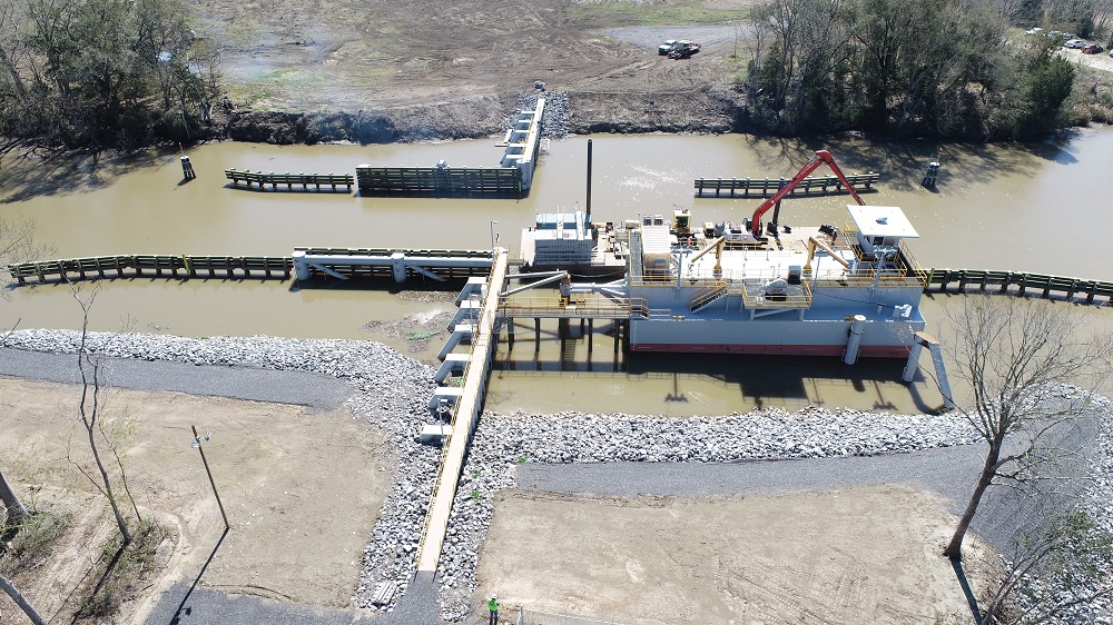
Bayou Chene Floodgate Structure
APTIM's Coastal Sciences & Engineering team planned, permitted, designed, and managed the construction of the Bayou Chene Floodgate, the largest of its kind in the world.
To stop the backwater flooding from the Atchafalaya River during high water events in the Mississippi River and tributaries system, APTIM planned, permitted, designed, and managed the construction of a floodwall, floodgate structure, and levees, which:
- Helped protect 30,000 coastal residents from backwater flooding in six coastal Louisiana parishes (counties)
- Demonstrated global leadership as the largest floodgate of its kind in the world
- Marked an ongoing relationship with St. Mary Levee District (SMLD) following three previous, successful emergency projects in 2011, 2016, and 2019
Project History
In May of 2011, rising water levels in the Mississippi River threatened the cities of Baton Rouge and New Orleans and their surrounding communities. To alleviate downriver levee stress and lower risks of levee overtopping, the US Army Corps of Engineers opened the gates of the Morganza Flood Control Structure in central Louisiana. While diverting a sizable volume of water from the Mississippi River into the Atchafalaya Basin helped prevent downriver flooding, the additional water in the Atchafalaya Basin threatened St. Mary, Terrebonne, Lafourche, St. Martin, Assumption, and Iberville parishes.
To combat this threat, SMLD constructed a temporary flood protection structure in Bayou Chene, preventing approximately 5 feet of water from flooding the affected parishes. APTIM’s team managed the procurement and Federal Emergency Management Agency Project Worksheet Program for the 2011 disaster. Following proven success of the 2011 event, SMLD retained the services of APTIM and a team of subconsultants, including T. Baker Smith, Inc.; Miller Engineers and Associates, Inc.; FTN Associates; and Eustis Engineering Services, LLC, to permit and design the Bayou Chene Flood Protection Structure.
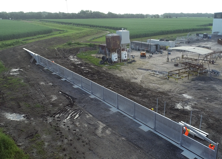
In 2016 and 2019, high-water events again threatened the surrounding five parish area. APTIM was contracted during both these events to design emergency structures to prevent backwater flooding from the Atchafalaya River. In both cases, the structure was designed, bid, and constructed in 15 days or less. In 2016, existing wing walls from a previous flood were used, while the Terrebonne Levee & Conservation District and the Southeast Louisiana Flood Protection Authority-West provided additional support, labor, and materials in 2019.
As part of the permanent program, a floodwall, gate structure, and levees were proposed in and surrounding Bayou Chene to be closed to stop the backwater flooding that travels northeast from the Atchafalaya River during high water events in the Mississippi River and tributaries system.
Services Provided
The APTIM team provided planning, permitting, design, construction management, and engineering for the following phases:
- Phase 1A: Clearing and grubbing along Tabor Canal
- Phase 1B: Dredging first lift of South Levee Tie-In and Tabor Canal Levee and Shoreline Protection
- Phase 2: Receiving structure, floodwalls, North Levee Tie-In, guidewalls, and demolition of existing emergency structure
- Phase 3: Floodgate, pivot pile, and mooring structures
- Phase 4A: Avoca Road Levee
- Phase 4B: Tabor Levee & Weir
- Phase 5: Shore Power
The flood protection structure was functional for the 2022 high water season, and Phase 5 was set to be completed by the end of 2023.
Learn more about APTIM’s Coastal Sciences & Engineering services.


APTIM. In Pursuit of Better.
Connect with APTIM
Speak to a member of our Coastal Sciences & Engineering team.
Subscribe to the APTIM Xchange Newsletter
APTIM's newsletter, The APTIM Xchange, provides industry news flashes, regulatory updates, service spotlights, and topical columns from our subject matter experts.